Introduction
This paper seeks to collate together information on the changes the Strawberry Heights area has undergone over the last century, with regards to land/terrain, climate, land-use, vegetation, and ecotype. I begin by defining the bounds of what constitutes “Strawberry Heights” for the purposes of this paper, following which I summarize the area’s physiography with regards to climate, surficial geology, and soil type. A summary of the area’s wildfire history is then forwarded, focusing on two major wildfires which occurred in the summers of 1991 and 2003, respectively. Information is included on post-wildfire conditions and the ways in which said conditions have evolved in the years post-fire; in the instance of the 1991 wildfire, some degree of reforestation was conducted, while little to no reforestation procedures were initiated following the 2003 fire. Closing out the pre-field day section of the report is a short paragraph on the engineered waste facility proposed for construction at Strawberry Height’s low-elevation southwestern corner.
Following collation of the above information, a field day was conducted largely as a means of connecting my remote understanding of the area – gleamed from historical airphotos and literature review – with the lived-in, personal understandings of my dad Allan Casimir – former Range Manager for Kamloops Indian Band – and my uncle Russell Casimir – former Councilor for Kamloops Indian Band. Accomplishment of this connection was sought through the marking of notable sites, pointed out by my dad and uncle, on a georeferenced 1948 map that I created for the field – 1948 being the very period during which my dad, then a year old, was living up at Strawberry Heights with his parents. Knowledge from the field day is organized here in roughly chronological order in terms of the era to which given pieces of information refer.
Finally, historical airphotos for the area are collected and analyzed with an eye towards identifying and confirming changes weathered by Strawberry Heights over the years, with evidence of wildfire and logging being most notable.
Strawberry Heights
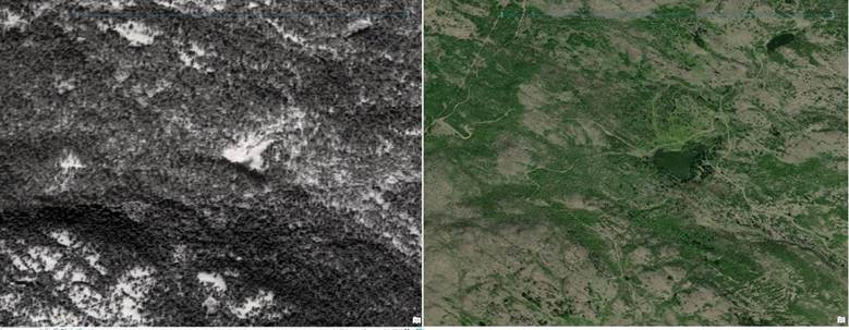
Strawberry Heights, known in Secwépemctsín as Stswékstem, and also referred to somewhat interchangeably as Strawberry Hill (see Lebourdais’ 2022 Archaeological Impact Assessment, where Stswékstem is referred to parenthetically as Strawberry Hill on page 7’s second paragraph, yet then referred to parenthetically as Strawberry Heights in page 9’s second paragraph), and Dome Mountain (see coverage of both major wildfires, 1991 and 2003), is a mountainous region located east of the North Thompson River within Kamloops Indian Reserve #1. For this paper’s purposes, the bounds of what constitutes “Strawberry Heights” are to be defined through consultation with my family members and may differ from the formalized geographical bounds of the land feature registered officially as “Strawberry Hill” under the BC Geographical Names Office on June 6, 1927 (Province of British Columbia Geographical Names Information System n.d.). Differentiation between the bounds of Strawberry Heights and Strawberry Hill may be undertaken and defined if warranted. As of now, my current delineation of the area’s bounds encompasses both “Strawberry Hill,” located east of the community of Rayleigh, as well as the “Dome Hills” located to the south of Strawberry Hill and north of Paul Creek (see photo below).
My particular awareness of Strawberry Heights stems from knowledge of my own family history; following my father’s birth in 1947, he lived with his parents Frederick and Nancy Casimir at Strawberry Heights, adjacent to his grandparents Thomas and Sadie Casimir. Both families logged timber on the mountain, living there part time before moving permanently to the lower reserve lands following my grandfather Frederick’s death in October of 1952.
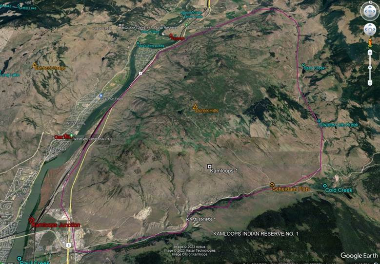
Google Earth Pro image illustrating, in purple outline, the roughly defined bounds decided upon for Strawberry Heights for this paper’s purposes. The feature “Strawberry Hill,” unmarked here, is located towards Strawberry Heights’ northwest corner.
Physiography
Strawberry Heights lies to the east and southeast of the North Thompson River valley, north of Mount Paul and Mount Peter, and west of Mount Lolo and Mount Fleet. Elevations within the area range from roughly 350 to 1180 meters, though the bulk of Strawberry Heights’ area falls between 800 to 1150 meters elevation, declining towards the north, south and west, with Strawberry Hill’s peaks in the north trending somewhat lower elevation than the Dome Hills to the south. To the east, lower portions of the study site span no lower than roughly 700 meters elevation before rising again in approach of Mount Lolo to the northeast and Mount Fleet to the southeast.
More broadly, the Thompson Plateau physiographic region to which Strawberry Heights belongs is defined by low relief (low elevational variation) uplands formed by erosion during the late Tertiary period, generally falling between 1,200 to 1,500 meters elevation, with severely eroded portions dissected (severely, sharply eroded) by the North and South Thompson River and their attendant tributaries (Holland, 1976).
Descriptive physiographic information pertaining to two lower-elevation sites at opposite northwest and southwest ends of Strawberry Heights has been published by Newman and Wallace (2017) and Lebourdais (2022), respectively. The former site is located 10 km north of Kamloops (at 50°47′ 40″ N, 120° 17′ 44″ W) and falls between 650 to 750 meters elevation within the 650 ha Raleigh Pasture of the Seven-O ranch grazing lease (Newman & Wallace 2017, p. 9), while the latter lies 4 km northeast of Kamloops and below 450 meters elevation in the location of the current Tk’emlúps landfill and proposed engineered waste management facility (Lebourdais 2022). While descriptions pertaining to the two sites are unlikely to encompass the whole of the natural phenomena around Strawberry Heights, much of it is likely representative enough to be extrapolated to the area’s remaining span.
For the Newman & Wallace (2017) site, plant community was said to compose a 70:30 ratio between forest and grassland in the former’s favour; mention is made too, uncited, of a large proportion of the area having been logged in the mid-60s (particular scrutiny should be given to air photos from this era to determine extent of logging and if said logging was the largest driver of deforestation in the area prior to the major fires – or not). Of the area’s forested ratio, 65% was composed of 115 year-old Douglas-fir trees to 30% 175 year-old Ponderosa pine trees (Newman & Wallace 2017). Grassland portions of the area were comprised of bluebunch wheatgrass, needle-and-thread grass, and mixed grassland forbs, with rare, uncommon occurrences of rough fescue and pinegrass (Newman & Wallace 2017).
In discussing the natural setting of her study area, Lebourdais’s (2022, p. 10) paper extrapolates information on the topography and surface geology of her study site from the Fraser Glaciation which “covered the region in ice sheets 2km thick in some deep valleys,” including the majority of the North and South Thompson Valleys, which became saturated with glacial meltwaters. Gradual deglaciation within the region eventually gave way, following a cataclysmic flood event of the interior glacial lakes, to erosional downcutting of glacial deposits by local river and stream systems (Lebourdais 2022).
Bedrock Geology
Strawberry Heights is underlain by four distinct bedrock types which are roughly oriented northwest to southeast. They are as follows: A Cenozoic-aged bedrock consisting mainly of undivided volcanic rocks of the Kamloops Group, as well as minor fine grained sedimentary rocks, a Paleozoic-aged bedrock largely composed of sedimentary rocks of the Harper Ranch Group in addition to some minor volcanic rock presence, a Mesozoic-aged bedrock composed mainly of sedimentary rocks of the Nicola Group, and, located in a small Northwest portion of area, a Mesozoic-aged bedrock not classed as belonging to any group and composed of intrusive rocks of the Triassic to Jurassic geological period. These mapped bedrock units are in broad agreement with field observations made on August 23, 2023.
Surficial Geology
The Strawberry Heights area is characterized by alluvial deposits in the valley bottom adjacent to the North Thompson river, a mix of fan and undifferentiated deposits on the lower valley sides, and bedrock dominated middle hillside slopes covered with a veneer of colluvium. The upper hillside is covered with morainal deposits including drumlinoid-like (elongated, oval-shaped hill) features and also features areas of exposed bedrock.
Biogeoclimate
The bulk of Strawberry Heights falls into the IDFxh2 zone (Thompson Very Dry Hot Interior Douglas-fir), including Newman & Wallace’s (2017) study site. A smaller portion of the area snaking down from northwest to south is classified as a PPxh2 zone (Thompson Very Dry Hot Ponderosa Pine. Lower elevation portions hugging the northwest to southwest perimeter of Strawberry Heights (into which the proposed engineered waste facility Project Area falls) are classed as falling within the MGxh2 zone (Thompson Bunchgrass Very Dry Hot), while a portion of the area spanning from Schiedam Flats in the south to Strawberry Hill’s western portion is categorized as belonging to the BGxw1 zone (Nicola Very Dry Warm Bunchgrass). All four zones are classified by iMapBC as “Ecosystems with frequent stand-maintaining fires.
Climate Trends
A point was chosen upon a Climate BC map, located at the summit of the feature formally called “Strawberry Hill,” at 50.805 latitude and -120.236 longitude at an elevation of 1013 meters, intended as representative for much of the Strawberry Heights area.
During the period between 1991 and 2020, mean annual precipitation for this selected point was 428 mm per year, with 112cm of that precipitation falling as snow. Mean annual temperature was 5.5 degrees Celsius. The bulk of the precipitation occurs during summer and fall. For the period between 1951 and 1980, mean annual precipitation for the area was 378 mm with 122cm of that precipitation falling as snow. Mean annual temperature was 4.6 degrees Celcius, and the majority of precipitation occurred during winter and summer.
A point of lower elevation overlooking the North Thompson River was selected at 50.768 degrees latitude, -120.324 degrees longitude, and an elevation of 451 meters. Mean annual temperature for this point was considerably higher than for the 1013 meter elevation point, at 8.5 degrees for the 1991 to 2020 climate normal period, and 7.6 degrees for the 1951 to 1980 period. Mean annual precipitation for the 1991 to 2020 period fell at 342 mm with 53 mm (snow water equivalent) falling as snow, while the 1951 to 1980 period saw mean annual precipitation number at 287 mm with 67mm of the precipitation falling as snow.
Analysis of climate normal data therefore suggests that mean annual temperatures are increasing over time, as is total precipitation, and the seasonal timing of highest precipitation appears to be gradually shifting from winter and summer to summer and fall.
Future Climate Projections
According to ClimateBC’s Future forecasts for the selected point, the best-case (low emission) scenario for the 1013 elevation point area’s future climate between the 2041 to 2070 period (ssp126) was projected to entail a mean annual temperature of 7.1 degrees Celsius, and a mean annual precipitation of 459, with 101 cm of that precipitation falling as snow. Precipitation was notably quite close to even in distribution across the four seasons, with spring subject to the lowest precipitation levels. Minimum temperature for January averaged across the month was forecast at -9.2 degrees Celsius, while maximum averaged temperature for July was 25.6 degrees Celsius.
The worst-case scenario for the area’s future climate for the same 2041-2070 period (ssp585) was projected to entail a mean annual temperature of 8.3 degrees Celsius, and a mean annual precipitation of 462 mm, with 83 cm of that precipitation falling as snow. Precipitation levels were seasonally skewed towards winter, with autumn falling close behind. The minimum averaged temperature for January in this scenario was forecast as -8.5 degrees Celsius, while maximum averaged temperature for July was projected to be 27.1 degrees Celsius.
In terms of contrasts between this projected future scenario with past climate normal data, differences are most pronouncedly apparent with regards to minimum averaged temperatures, with the 1991 to 2020 climate normal period’s average January minimum temperature of -6.8 falling nearly two degrees below that of the worst case scenario’s average minimum temperature for same. Average maximum temperature for July within the 1991 to 2021 climate normal period, however, was in fact higher than that of the worst-case scenario’s maximum average July temperature by 0.6 degrees.
Interestingly, the wetter conditions projected for the area may be suggestive of greater future amenability towards tree growth, which could possibly cut against the area’s post-wildfire transition to grassland to some degree, and perhaps ease the process of reforesting the previously densely treed mountains if such an initiative were undertaken.
Soil Types
Soil types vary quite widely along Strawberry Height’s breadth; generally, silty loam Mossey (of Orthic Black Chernozem class, common to the area) and sandy loam McLaren (of Orthic Gray Luvisol class) soils predominate, both well-drained. McLaren soils largely underpin the most forested portions of the area, while well-drained, silty loam Maiden soils also underly a dense portion of forest towards the West. Around the area’s lower elevation perimeter, various well to rapidly-drained soils occur, with sandy loam Gwenn (of Orthic Black Chernozem class) soils predominating to the North and South.
Wildfire History
1991:
A major wildfire at Strawberry Heights, referred to as the “Dome fire,” initiated the afternoon of August 3rd, 1991, eventually burning 573 hectares and incurring 800,000 in firefighting costs (Kamloops This Week 1991, p. 3). Classified as “contained, but not controlled” on August 8th (Kamloops This Week 1991, p. 5), the fire was considered under control by the 11th of the same month, but still in requirement of “several weeks” worth of clean-up before it could be considered officially extinguished (Kamloops This Week 1991, p. 1). Evidence indicated the fire as human-caused – possibly owing to a still-burnt cigarette butt (Kamloops This Week 1991, p. 1). Firefighters on the site numbered at around 140, and access to equipment and resources to fight the fire – regarded as unusually large for the period – was considered sufficient (Kamloops This Week 1991, p. 1). My father Allan Casimir – range manager for Kamloops Indian Band during the time – recalls a period of inaction following the fire’s initiation, in which wildfire response procedures were held back for want of official classification of the event as a wildfire.
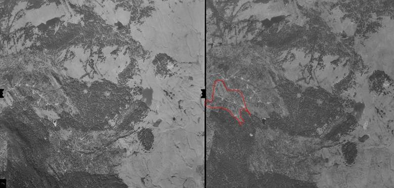
Comparison of air photo images from 1986 (left) and 1992 (right), respectively, with purple arrows pointing towards burnt sites.
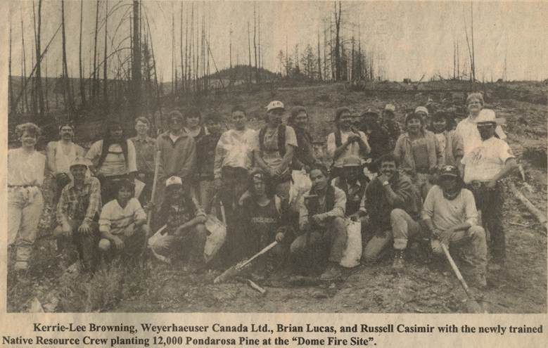
Less than two years following the fire, 12,000 Ponderosa Pine trees were planted in partnership with Weyerhaeser Canada Ltd at the site of the wildfire by my dad’s then newly trained Native Resource Crew (see photo below, and see Field Day section for more information and another photo). Prior to this, in October of 1991, Kamloops This Week (1991, p. 1) covered the planting of 200 yellow pine seedlings undertaken by 50 members of the Junior Forest Warden Project, lead by Forest District manager Bob Miller.
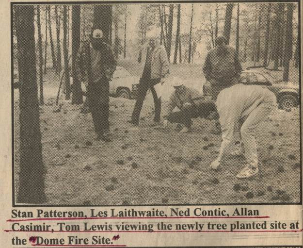
Photograph published in Lex’yem, the Kamloops Indian Band Newsletter, March 1993.
2003:
The 2003 Strawberry Heights fire (K20298) occurred concurrently with the massive Mclure/Barriere fire, beginning August 1st – two days after the McClure fire’s July 30th initiation. The fire initiated on Highway 5’s east side, adjacent to the community of Rayleigh (Newman & Wallace 2017); initial growth was rapid, ballooning to football field size within a five-to-ten-minute span (Road Runner 2003), eventually encompassing 5,731 hectares in total (Newman & Wallace 2017). Evacuation orders for residents of Rayleigh and Heffley Creek were issued near-immediately, with wildfire interfacing as closely as 45 meters from residential homes (Road Runner 2003). Effects on wildlife were described as “staggering” (Road Runner 2003, p. 2). Informal testimony from the period held that the 2003 fire, like the previous 1991 fire, was human-caused – this time apparently owing to a lit cigarette thrown from a car window (NSMN 2003).
Vegetation burn severity within the area was classified as high, consisting of uniformly dead and blackened canopy tree conditions, full needle consumption, near-total woody debris consumption, and at least partial burning of the understory (Newman & Wallace 2017). Soil burn severity, described by Wallace and Bryan (2017, p. 8) as “a more sensitive indicator of damage to underground plant structure and propagules than vegetation burn severity,” was classed within a moderate-to-high severity range following site inspection by the authors.
Post-fire understory plant survival was very low, with most surviving plants located in rocky areas (Newman & Wallace 2017). Eleven months following the fire, 25 plant species total were recorded, each belonging to one of four categories; fire survivors such as pinegrass and balsamroot, windborne invaders such as common dandelion and prickly lettuce, colonizing seed bankers such as timber milk-vetch, and seeded species such as rambler alfalfa (Newman & Wallace 2017). None of these 25 species spanned above 0.4% ground coverage individually, and only 8 of the 25 spanned above 0.1% coverage (Newman & Wallace 2017). During this same time, ground surface coverage in the area was composed of 1.5% litter, 87.5% exposed mineral soil and 8.2% rock; this condition however saw rapid change in the following years as litter, vegetation and crustal development engendered a vast decrease in mineral soil coverage to 12% 4 years post-fire (Newman & Wallace 2017). Notably, this decrease was secured near-irrespective of whether a given area had been deliberately seeded or not (Newman & Wallace 2017). Benefits of seeding trials at the site – initiated in spring of 2004 – seemed mainly limited to the reduction of wind-blown weed germination and the securement of enhanced forage availability in the early years post-fire; in addition, the seeding may have negatively acted to impede the post-disturbance event succession process of the area’s indigenous plant community (Crown Managers Partnership, n.d.).
Precipitation for the area in May of the following year fell at ranges double that of Kamloops’ expected normal; overall, precipitation throughout 2004’s growing season fell at an average of 37% above normal (Newman & Wallace 2017). Testing undertaken in 2005 – almost two years following the fire – identified moderate amounts of soil surface hydrophobicity (Newman & Wallace 2017).
A March 2012 post on the website Kamloops Trails described the then-current conditions of the Strawberry Hill plateau, noting a surprising number of unburned trees remaining in the fire’s wake, buoyed further by young trees apparently the result of reforestation efforts, then about one foot high (Kamloops Trails 2012). Marshes and ponds were commonly sighted upon the plateau, and hillsides were studded with aspen trees and saskatoon berry bushes, with coniferous trees found at some sheltered, higher elevation spots (Kamloops Trails 2012.) The change in land-type – from open forest to grassland – incurred by the 2003 wildfire is suggestive of Strawberry Heights as being located within a zone of steep ecological transition, rendering the determination of land-type endpoints within the area highly susceptible to the influence of minor event changes (Newman & Wallace 2017). As the area becomes increasingly vegetated in the decades post-fire, the less likely it becomes that tree encroachment will be able to reach the levels necessary to engender a return to an open forest-dominating ecosystem within the area (Newman & Wallace 2017).
Subsequent fires
Four blazes started upon the mountain on July 1st, 2021, one of which grew to five hectares (Kamloops This Week, 2021); in March of the same year, a 16.2 hectare wildfire occurred in roughly the same area as the major 2003 wildfire (CFJC Today, 2021).
Engineered Waste Facility
In 2022, a 47 acre parcel of Strawberry Heights was assessed to identify any heretofore “unrecorded archaeological sites within the Project Area” (Lebourdais 2022, p. 7). This assessment was carried out in relation to the development of an engineered waste management facility within the assessed Project Area parcel, for which current land use was characterized as composing “a mix of undeveloped pastureland and the existing Tk’emlups landfill” (Lebourdais 2022, p. 7). Development proposals for the area entail vegetation removal and cutting and fill of impact zone sediments (Lebourdais 2022, p. 7). A single archaeological site, “TSN-EeRC-KG2,” was identified as a result of a 216 auger tests and a single shovel test (Lebourdais 2022, p. 3).
Field Day
A field day was carried out August 23rd, 2023, by a group consisting of my father Allan Casimir, uncle Russell Casimir, geomorphologist Gareth Wells, and myself. We roamed mainly about Strawberry Height’s mid-to-lower half by truck, spanning from the southmost bottom at Paul Lake Road to some ways northwest of the Dome Hills feature.
The day’s purpose was focused upon the collection of knowledge on changes weathered by the area over the years and the attendant development of land-usage in tandem with said changes, in a format in which information about the area could be marked upon points on a georeferenced map of the area in the iPad app Avenza. I also desired to incorporate a personal, cultural aspect into the mapping process, where understanding of the area as viewed upon my map would ultimately be guided by anecdotal history recounted by my family; an important part of the day was locating the site of my grandparents’ and great grandparents’ cabins. Commentary was given by my dad and uncle upon the changes enacted to the site following the two large wildfires that burned through the area, making clear their strong connection with the area throughout their lives; my dad spent his early years living with his parents in a log cabin on Strawberry Heights’ eastern side, and both brothers grew up using and managing the land within the area.
My dad – born in 1947 – spoke of later travelling up to Strawberry Heights with his parents as a child on horseback to camp, his father and grandfather fixing fence lines and putting up fence poles. Logging influence in the area was said to stem at least as far back as the 1930s or 40s, and logging involvement on the part of Kamloops Indian Band specifically was discussed to some extent, including the logging of deciduous trees like poplar and cottonwood, a unique trait of the band – “we’re the only band that got rid of all that cotton wood.” My family’s memories of the size of logged trees in the area provide some enlightenment as to the former state of tree stands, with trees then so wide in diameter that three would fill the back of a logging truck – a marked difference from what can be currently observed. History of road development was also touched upon, with my dad stating, “we were the first ones to start with the bulldozers, and put that big long road in here, and that zig zag road [built by Tommy Casimir, on the western side overlooking Rayleigh] cost 500 dollars.”
Context was given by my uncle Russell regarding the area’s neglected state following his move back to Kamloops in the late 70s, during which Strawberry Heights, “after all the logging and all the fires,” saw its roads grown over, seemingly for want of any activity or use in the preceding years. Russell resumed use of the roads and mountain during this period, and noted a vast change in land-use following the 1985 amendment to the Indian Act known as Bill C-31, which sought to “restore Indian status to those who had been forcibly enfranchised due to previous discriminatory provisions” (Indigenous Foundations n.d.), thereby increasing the number of people possessing inherent use rights towards the land: “they took over these mountains, they thought of it as their bonafide rights to come and use this land anyway they felt, and they raped and plundered this mountain, and they took out a lot of game out here, shooting everything, because they had inherent right now.” This identified shift – from apparent near-total disuse in the late 70s to overuse by the mid-to-late 80s, appears to me suggestive of a greater cultural shift in collective consciousness during this period.
The situation on the ground following the August 1991 wildfire’s initiation was discussed, with my dad stating, “we had two crews on top of the mountain, two firefighting crews, they could’ve went down and put the fire out; they said no, it’s gotta be declared a wildfire, so what they did was on the other side, they pulled up a trailer, they started about 6:30 in the morning, building a trailer and office. And about 7:30 at night, when the fire came up and over the mountain, the guys that were all there, the farmers and ranchers, [were] throwing their hats in the air [in response to having won the contract to fight the fire].” With much of the area badly burned following several weeks of active wildfire, Russell recalls “me and my brother, we got ministry, forestry, to pony up trees and we reforested that first burnout,” (see photo below) though said efforts were less broadly applied than had been their ambition – only a relatively small portion of burned forest, overlooking a gully on Strawberry Height’s western side, was replanted; “the front part is where we reforested it; we asked those guys in forestry to come back and do it all but they never did.” Of this area, Russell noted a long history of use going far back, stating that “I used to get spooked going in there, I would always see shadows and people moving by me, see people standing in the trees, so I went home and talked to my grandmother, both grandmothers, Angeline and Rosie, and they said that’s where the old timers used to go up in horseback and wagons and they would camp and hunt in the fall time, they would camp in that little gully.” My dad added, “they would do ceremonies out there, them days anything they did you had to have a ceremony, which nobody does now.”
Photograph published in Lex’yem, the Kamloops Indian Band Newsletter, March 1993.
Regarding the 2003 wildfire, near-total inaction was described with regards to post-wildfire remediation: “nobody came and did anything, that’s why you’ve got all these kind of trees; deciduous trees, that’s all that came out;” deciduous trees which had previously been subject to the band’s aforementioned logging efforts.
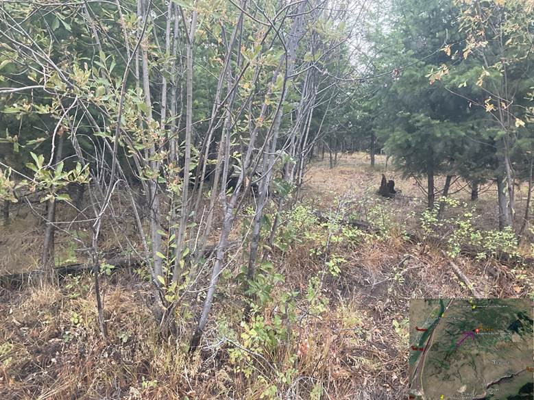
Signs of recent land management within the area appeared meagre, if not nonexistent, and contrasted with memories of prior land management initiatives undertaken in the area. Juniper trees appeared to be doing poorly, with small tree sizes observed and poor berry turnouts for the year, and bitter-berry trees and saskatoon berry shrubs were rarely if ever seen. A sizable portion of the land was densely grown in with deciduous trees and bushes, exerting a control on tree growth within the area that could be diminished were spacing and thinning procedures undertaken (see photo below). This dense deciduous growth stood in stark contrast to past conditions, with Russell recalling, “when I used to come up here you used to be able to see at least a hundred yards in, into the trees; now you can’t even see past the trees.” At one of our stops, by an unnamed lake, Russell noted that, while birch trees existed in the area in the past, it was not to the same extent as now; in the past, Douglas fir and Juniper trees predominated.
Area noted as in need of spacing and thinning; bottom right corner of photo shows where photo was taken on map, indicated by purple arrow and red dot – subsequent illustrative field photos will follow similar format.
Tussock moth caterpillars – known to kill off douglas-fir and ponderosa pine stands when moth populations reach high enough levels – were present on some trees in Strawberry Height’s southern portion (see photo below); though it was unclear how much damage the particular population we observed was causing to trees within the area, large-scale tree damage or mortality at the hands of said moths could be prevented by application of an isolated nuclear polyhedrosis virus upon local populations in the spring (BC Ministry of Forest and Range n.d.).
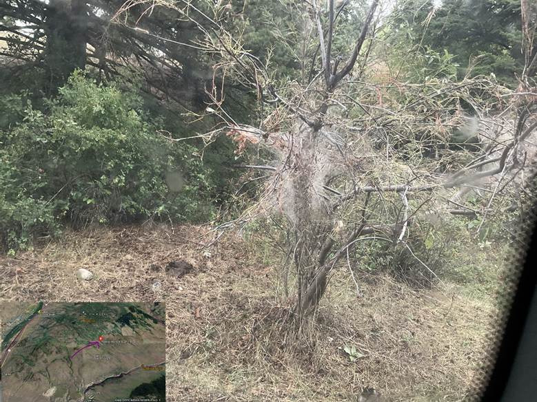
Cobwebbed trees bear tussock moth caterpillars, “eat up your trees.”
The likelihood of elevated erosional risks along the area’s creeks and lakes due to high, unmanaged deadfall concentrations in the circumstance of a high precipitation event was noted; previously, students were frequently hired in the summer to clear waterways of woody debris. Observing an unnamed lake we stopped at, Russell commented that in the past “they would have came up and cleaned this lake out – see all the deadfalls – they would’ve moved it back so the cattle could come and water. Nobody takes care of it.” Sagebrush – illegal to sell – appeared heavily picked in one area we drove through, apparently being sold on the basis of healing properties. A heavily eroded washout was spotted downstream from where an artesian well was previously located (see photo below), likely having fallen into disuse and/or disrepair over the years and leading to groundwater seepage.
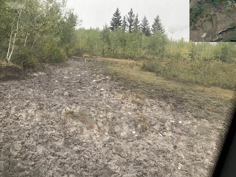
Washout downstream from artesian well.
Russell provided knowledge on medicinal uses of different plants found in the area; juniper tree leaves – used to cleanse the air in own’s home, bitter-berries – good for blood cleansing, bitter-berry plant roots – can be cleaned, boiled and used to clean out eyes afflicted by soreness or cataracts, and early spring poplar leaves, used for horse deworming. A wasp’s nest was also seen hanging about a meter from the ground, indicative of a mild winter in terms of snowfall: “if you find them up higher up in a tree it means the snow is gonna be deep,” Russell explained, in addition to making mention of some interesting healing properties wasp’s nests are said to possess; “that’s what the old people are always saying. If you take an abandoned wasp nest you’re supposed to bath in it and it helps clear up your skin and everything up.”
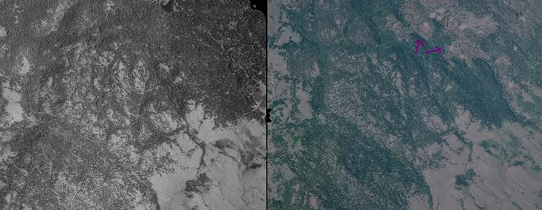
There appears to be obvious interrelation between the current state of vegetation on Strawberry Heights and the current land management practices – or lack thereof – undertaken within the area. There appears to be insufficient motivation to manage the land such that reforestation of the area could be better supported. Comparison of the current site with 1948 imagery following the field day renders stark the amount of change incurred over the years; the area within which we stopped by a lake, now patchy, oft-barren, and composed primarily of deciduous trees, appears densely forested right up to the lake’s borders in the 1948 air photo (see comparison below).
Left: Georeferenced air photo dated September 18, 1948 showing woods surrounding lake. Right: Recent Maxar air imagery showing same area.
Also of note, the area wherein lay the remnants of my grandparents’ and great-grandparents’ log cabin turned out to correspond with what is currently the most densely forested area within Strawberry Height’s bounds – a section likely unburned by the multiple wildfires that have swept through the area (see photos below).
Left: Georeferenced air photo dated September 18, 1948 including former location of cabins. Right: Recent Maxar air imagery showing same area. Overlapping of distinct georeferenced 1948 air photos is imperfect here, but note the upside down triangle feature at the bottom left side of the densely forested area in the current photo; it is present as a point of reference, indicated by purple arrows, in both the 1948 and recent air photos.
Overall, it was a special, invigorating day that allowed me to internalize a specific sense of place in relation to the stories my dad and uncle have told me over the years about the area, in a manner that further filled out my understanding of Strawberry Heights, following my preliminary reviews of air photos and relevant literature on the area. Since that day, my dad has been motivated to work towards the reinstatement of land management practices within the area, with ambitious plans to organize silvicultural work there in the near-future – a prospect leaving me truly excited about the future possibilities here, and the ways in which I could potentially help and learn as a result, to eventually carry out the sort of work my dad and uncle have.
Description of temporal changes identified from air photos, 1948-2004
Strawberry Heights – September 25, 1948 to present comparison, generalized: Vast difference in middle Strawberry Heights; much more forested overall in the 1948 airphotos, with majority of mountains covered in mature douglas fir and ponderosa pine timber. Differences present to a less extreme extent in upper Strawberry Heights spanning towards Rayleigh. Lower Strawberry Heights spanning down towards Paul Lake Road looks much the same; very similar (low) vegetation amounts apparent. Review of most recent imagery and field observations conducted on upper plateau area showcase some level of returning tree coverage post-fire, with deciduous trees dominating alongside some fir tree reestablishment.
Over the years, prior to the 2003 fire, forest in the middle-lower sections of Strawberry Heights appears to have filled in somewhat (compare, for instance, BC755-28 to 1997’s BCB97021-211, below)
The following is a more minute description of changes identified between each year of available air photos for the area:
Upper Right Portion: Comparing 1966 and 1974 photos, treed area in portions of the photo appear distinctly patchier – evidence of wildfire? Also seems that possibly new trails have been put in.
1974-1976: Smaller (red-circled below) treed area appears distinctly patchier
1976-1980: A new area (red-circled below) appears newly patch, while previously patchy areas appear somewhat greened up (green-circled)
1980-1984: No discernable change
1984-1986: Some possible greening up of (green-circled below) forest areas:
Lower:
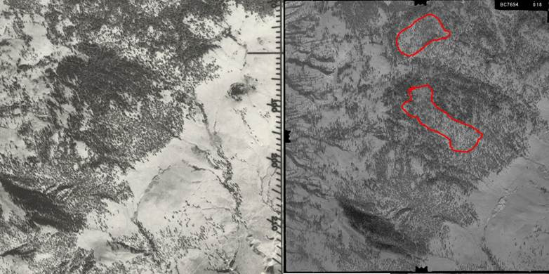
Comparing 1948 and 1966 photos, increased patchiness within the two red-lined areas is apparent, indicating some degree of wildfire and/or logging having occurred within the area between the time periods of the two photos.
References
BC Ministry of Forests and Range. n.d. “The Douglas-Fir Tussock Moth.” https://www.for.gov.bc.ca/rsi/foresthealth/pdf/dftm pamphlet_vs1.pdf
Crown Managers. n.d. “Brian Wallace – Crown Managers Partnership.” Crown Managers Partnership. https://www.crownmanagers.org/brian-wallace
Doug Collins. 2021. “Wildfire on Strawberry Hill brings back memories.” CFJC Today. https://cfjctoday.com/2021/03/17/wildfire-on-strawberry-hill-brings-back-memories/
Holland, Stuart. S. 1976. Landforms of British Columbia: A Physiographic Outline. The Government of the Province of British Columbia.
Indigenous Foundations. n.d. “Bill C-31.” https://indigenousfoundations.arts.ubc.ca/bill_c-31/ – :~:text=Bill%20C%2D31%2C%20or%20a,Charter%20of%20Rights%20and%20Freedoms.
Kamloops This Week. August 8, 1991. “Dome fire no longer danger.”
Kamloops This Week. August 11, 1991. “Rapid attack crews keep fires in check.”
Kamloops This Week. October 2, 1991. “Junior Wardens give new life to Dome.”
Kamloops This Week. October 30, 1991. “Fire costs up.”
KamloopsTrails. 2012. “Strawberries and Soot.” Kamloops Trails. https://kamloopstrails.net/2012/03/23/strawberries-and-soot/
LeBourdais, Leslie. 2022. Archaeological Impact Assessment of KIBDC Proposed Stswékstem (Strawberry Hill) Engineered Waste Management Facility Kamloops Indian Reserve No.1, Kamloops, BC. The Effect of School Closure on (tkemlupsbusiness.ca)
Ministry of Forests. 2003. Report to the 2003 Firestorm Provincial Review. https://www2.gov.bc.ca/assets/gov/public-safety-and-emergency-services/wildfire-status/governance/bcws_protection_submission_to_filmon.pdf
Newman, Reg. F., Wallace, Brian M. 2017. Vegetation Response to Post-wildfire Seeding: Strawberry Hill Wildfire. Forests, Lands and Natural Resource Operations.
NSMB. 2003. “Rose Hill!! – NSMB.com Forums.” https://nsmb.com/forum/forum/the-shore-3/topic/rose-hill-120358/?post=2235010
Road Runner. 2003. “Fires rage across interior for weeks.” https://www2.gov.bc.ca/assets/gov/driving-and-transportation/reports-and-reference/road-runner/newsletters/2003_10_fall.pdf